 Why You Can Trust CNET
 Google Maps for Android review: The best maps app you'll find on Android
Google Maps for Android was just rebuilt from the ground up, and now it looks better, has more features, and offers a custom experience for individual users. As good as it is, though, it still has a bit of room for improvement


The newest version of Google Maps for Android offers one of the most robust mapping experiences I've seen. Long a staple in every Android user's app drawer, the app has gone even further this week, with the additions of personalized mapping experiences, recommendations, more Zagat integration, and more. Further, all that Google Maps has to offer has been packaged in a cleaner, more minimal interface that's optimized to your screen, whether you're using the app on a tablet or a smartphone.
Google Maps for Android
The Good
The Bad
The Bottom Line
But as good as the new Google Maps app is, it's important to note that the added improvements did come at a cost, as a few important features have been changed and altogether removed. For instance, some users will be disappointed to see missing map layers from versions past, and an offline caching feature that has been notably downgraded. Still, with its handful of imperfections in tow, its hard to argue that there's anything better for your mapping needs than Google's default mapping application.
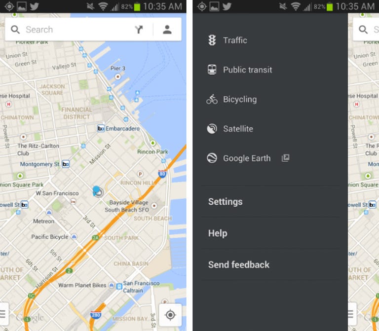
Map basics
The new Android app breaks the map out of the box and covers your whole mobile screen with map data, with the only interface elements being a floating search box up top, a button to pinpoint your current location on bottom, and a slide-out menu on the left. As a whole, Google Maps is cleaner than ever and runs more smoothly as well.
When viewing a location, Google Maps lets you activate add-on layers for traffic, transit lines, satellite images, and bicycle routes, all of which are useful. However, dedicated Maps users will notice that a few layers are now missing, including those for Terrain, Wikipedia, Latitude, and My Maps. I find the missing My Maps layer to be particularly upsetting because I often create detailed maps of destinations to which I am traveling, but now I can no longer overlay them in my mobile app.

One of the biggest selling points of the new Maps is the way it offers a different experience for every user. Specifically, it plots out points of interest that are relevant to you, based on your search history, social data (from Google+), and reviews history. Overall, this creates an incredible Maps experience that makes discovering new restaurants, bars, and other points of interest easier than ever before.
One thing I love about Google Maps for Android is that it lets you cache maps for access while offline, which can be hugely useful while traveling. The bad thing is, the feature, while it has been built into the app for some time, is now more difficult to access. In the newest version of Maps, you need to speak or enter "OK Maps" into the search box in order to save the current map for offline viewing. Not very intuitive, right? What's more, there is no way to select a specific area to save or to see how large the cached file will be, which is problematic. Previously, all you had to do was tap "Make available offline" and drag a box around the desired area, which was a much simpler process.
Search and Explore
By now, we're probably all familiar with the power of Google search. Within Maps, whether you're searching for a specific address or a general term like "pizza," all you have to do is type it into the new floating search box and watch as Google tries to autocomplete and figure out what you're looking for. Once you settle on a specific location, results immediately populate the map below, with Google Now-style info sheets sitting on the bottom of the screen. You can swipe to scroll through different results or tap to see more details, photos, Zagat reviews, and so on. Alternatively, you can hit the list icon to pull up results in a list form, though there's no way to sort this list by things like distance or rating.
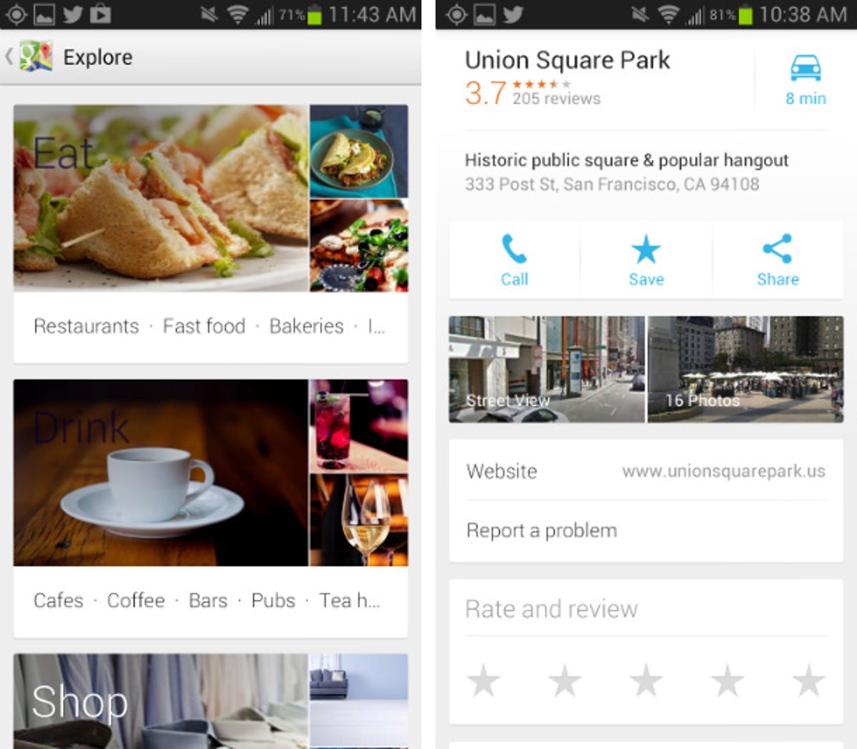
If you're not exactly sure what you're looking for, you can now ask Google Maps for suggestions by using the Explore function, which is not unlike that of Foursquare. With this tool, you'll get info cards for a number of categories, including Eat, Drink, Sleep, Shop, and so on. And because recommendations are based largely on Zagat reviews, they can be a big help in finding popular spots in unfamiliar cities.
Speaking of Zagat, the reviews platform is now even more deeply integrated, as star ratings are front and center on a business' info sheet. Also, you can now rate and review businesses right from within the app, so watch out, Yelp.
Indoor maps and Street View
For some buildings, you can zoom in and get indoor maps. A number of malls, museums, and airports around the world are supported, and the list is growing rapidly. Once you're peering at an indoor map, you can even switch floors using the slider on the side of the screen, making Google Maps a great alternative to shopping-mall directories.


And, of course, you can get Street View on the Google Maps app as well. You can activate it right from an info sheet, and some businesses even offer indoor views so you can have a 360-degree look around inside as well. What you don't get in Google Maps, though, is the 3D flyover view. For that, you'll need to jump over to Google Earth.
Navigation and directions
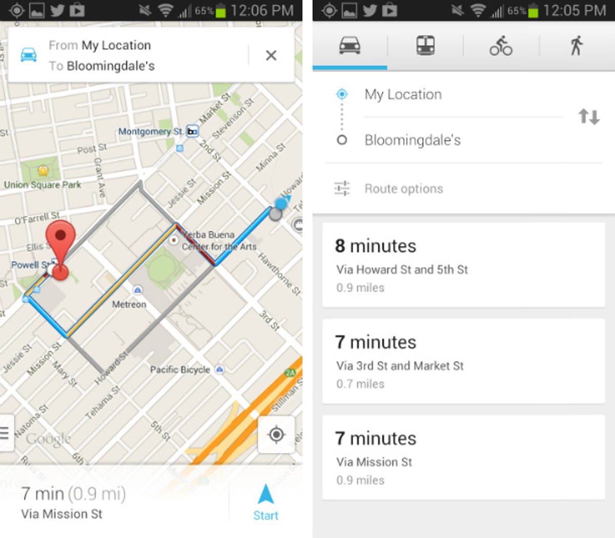
One of the most important aspects of Google Maps for Android is directions. The app lets you easily conduct a search for a destination with text or voice, so you can get directions for driving, public transit, walking, or even biking. I've been consistently impressed with the number of walking paths and bike trails that are viewable through the app, and the public transit directions offer several different options if you'd rather take a train than a bus or vice versa. And to make things easier, the app even suggests the best mode of transportation by default and plots out different routes on the map for you to quickly compare. In the end, whichever mode you select, you can read your route in list form or map form, or hit the arrow icon to activate voice-guided turn-by-turn navigation.
When it comes to routing, Google Maps' navigation usually works well, though I have seen it suggest inconvenient routes in very specific instances. For example, I've had Google Maps route me around the block, when a simple U-turn around a traffic island would have sufficed. That said, I still consider its navigation reliable and I generally trust it to get me from point A to point B. It gives ample warning leading up to turns, and I like that it even gives a warning when you have to make two quick turns in a row.
One thing I love about the improved Google Maps' navigation is that it constantly takes into account current traffic conditions, and it feeds you information about road incidents ahead of time. In fact, if you hit a traffic jam and there's a better route available, Google will automatically notify you, so all you have to do is hit the Reroute button. Alternatively, if you simply veer off a selected course, the app will reroute you automatically.
Final thoughts
For a fast and powerful mobile mapping experience, it's hard to beat Google Maps for Android. This feature-fest goes far beyond a simple piece of mapping software with its turn-by-turn navigation, voice search, indoor mapping (select locations), Street View, Zagat reviews, and more. Further, if you use Google Maps on your other devices while signed in to your Google account, your search history and saved places all sync to the app seamlessly.
At this point in the game, there's not much in the marketplace that can hold a candle to Google's preinstalled Maps offering. Of course, you could try MapQuest, but its feature set doesn't come close. Very simply, if you need a map on your phone, then skip the competition and stick with Google Maps.